I may receive a commission from a purchase. See more details here.
- TexyHills
- Maps
Texas Hill Country Maps
Texas Hill Country Maps are Great!
That is... if they have what you are looking for.
I am old enough to remember using paper maps to get around in unknown territory. That meant that I'd have to stop to check out the paper map. Or... I would rely on a my navigator (Judy) to help me know when and where to turn.
If you are getting a little impatient with my rambling on about maps history, here is a preview of what I am working towards.

This map is also shown below, but I thought you might want a sneak peak.
And if you need to dive a little deeper into my maps, check out the Ultimate Guide.
I have even more maps, if you feel the need.
Now, back to my ramblings...
Our Changing Times
Today, as you know, maps are digital. They are easily pulled up on computers, tablets, phones, and dash navigators. I have basically quit using paper maps. And... I know some of you out there have never used a paper map.
Don't you love it!
 Texas Hill Country by Google
Like I said... maps are great, if they show what you are looking for.
But if they don't, you are off looking for a different Texas Hill Country map that has what you want. Right?
The example above is a photo. You can see Texas and what surrounds it. There are only a few towns and roads. And I drew an oval in the middle to show you about where the Texas Hill Country is located.
The map shows what it needs to, but not much more. And... it's a photo. So it can't be changed.
Texas Hill Country Maps and Beyond
This form of a Google map, though, gives you a little more flexibility. You have a zoom capability, as well as an option to drag the map to different locations. And even a satellite view.
And, the view larger map icon will give you a full screen view with even more options.
Just being able to zoom in and out helps with big picture views and closer details. So this type of map would be much better than just a picture.
Another great thing about various Texas Hill Country Maps, is that they can help you plan a day trip, a driving tour, or a weekend getaway. They give you route options.
In this example below, a trip from Austin to Boerne shouldn't take much more than a couple of hours. Of course you choose the route (through the Texas Hill Country or along the Interstate).
And, you may want to make stops along the way... for lunch or whatever.
Very handy. I use them all the time, too.
Maps are not only helpful like this, but they're also fun to use.
Well... I think they are fun.
Getting Around
Most cars on the road today have navigation systems in them. So it's easy to recalculate a route, create a different route, or add an out of the way stop on the way to your final destination.
 Today's navigation systems... what would we do without them?
Oh... I can't leave out an example of a satellite view.
I Can Do That
Did I hear you say... "I can do that. I can get a map whenever I want."?
Yes. Of course you can do that.
You've got it covered. I know you have probably been using digital maps on your phone and in your car for a long time.
As you can tell, most of what I have been talking about here is fairly basic (useful but basic).
My intent here, though, is not to dazzle you with new tech or something you've never seen before. It is simply to present something useful and worthwhile for someone.
Just as an example, this page about bluebonnets gives you a few route possibilities. It's definitely something you could do for yourself... but isn't it nice if you don't have to?
Plan My Fredericksburg Wine Weekend in 30 Minutes
- 3-day Itinerary Templates (printable + fillable)
- Curated drive loops + Google Maps links
- Reservation plan + Plan B library
But if you've got it covered... no problem. Technology is great, right?
If you happen to want a short quick-read guide, check out this Hill Country planning guide.
Maps are more than towns and roads
As well as specific routes (road trips), maps can also show points of interest, wineries, places to stay and eat, etc. (with info about each).
So even though all of this is something you can do for yourself, a few scenic drives all located in one place might trigger a few new travel ideas. Maybe even an idea that never before occurred to you, about where to travel next.
And if these maps are also interactive... well, that's a big plus. So I'm thinking that an interactive map, loaded with additional specific information, might even be more helpful.
This TexyHills map is an example of what I mean by interactive. It is powered by Google, but has information specific to the Hill Country.
When you click on the "View Larger Map" icon in the upper right, it will open up into a full screen view.
On the left you will see a list of options (Towns, Wineries, etc.) that you can check or uncheck to see different information on the map.
When a selection is checked, the down arrow will open up even more information, grouping locations by town. (The towns are grouped by County.)
And beyond that, when you click on an individual icon shown somewhere on the map, additional information pops up on the left about that particular winery, restaurant, etc.
Same thing - different view
If that map version is a little too busy, with too much information, here are a few less crowded versions.
These maps show the same information as the TexyHills map, but less cluttered. They may be less confusing if you are only interested in certain types of locations.
- Map showing only Restaurants.
- Map with only Lodging.
- Only towns on this map.
- Wineries and Vineyards on this one.
- A Lakes map.
- A map with Points of Interest.
So, look for changes and additions here as time goes by. Hopefully, as the number of maps grows, and the information on them increases, some of you will find it interesting, if not helpful.
Happy travels.
What do you Think?
If you think there is something that should be added to one of the TexyHills maps, just let me know. Send me a suggestion and I will see what I can do.
think ahead and keep on planning
If you just get in the car and go for a drive to enjoy the scenery, you may not need to plan much (except for remembering to take your phone, ID and some cash).
But if your plans will include a girls' weekend or full blown wedding, a little thinking ahead is a must.
I understand your level of planning will vary depending on how elaborate and involved you want your trip. So, maybe these resources will help you decide what level of planning you want.
- TexyHills Checklist - A short 1-page list of 10 things to book first, for a smooth weekend. Yours free when you sign up for the TexyHills Fan Newsletter.
- TexyHills Planning Guide - An easy quick-reference to help you think about when to visit, getting around, avoiding big crowds, etc.
- Ultimate Texas Hill Country Guide - A much more comprehensive guide including maps, itineraries, where to stay, etc. It also has a table of contents for easy navigation.
- Fredericksburg Wine Weekend - My most complete done-for-you 3-day plan, reservation strategy, and curated drive loops (with a built-in Plan B). Specifically for first-timers.
What's New?
-
Hill Country Travel Guide is for preventing unexpected situations.
Hill Country Travel Guide gets you thinking about your routes, budget, activities, weather, crowds, traffic, etc. so you don't run into anything unexpected. -
Fredericksburg Texas Lodging is so widely varied that everyone wins.
 Fredericksburg Texas Lodging puts you in the middle of wine country. You also get the benefit of the history, comfort and convenience of your surroundings.
 -
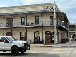
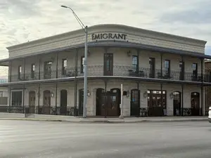
Emigrant Boutique Hotel, located right on Fredericksburg's Main Street
Emigrant Boutique Hotel's recent update makes it the kind of stay that sticks with you long after you've checked out. Yet it draws you back again and again. -
Texas Hill Country Maps are the ideal planning tool before a trip.
 Texas Hill Country Maps can help you get ready ahead of time, before you take off into the Texas Hill Country. Plan your route and know your destinations.
 -
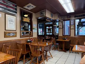
Union Station Diner is the place where friendly folks meet and eat.
Union Station Diner is located in a historic area of New Braunfels, Texas. They serve up traditional American food with excellent service at affordable prices.


Brought to you courtesy of jeff slankard
 with wife Judy at Wildseed Farms") Daughter Ranita with Shane, and me (Jeff) with wife Judy at Wildseed Farms
Daughter Ranita with Shane, and me (Jeff) with wife Judy at Wildseed FarmsJeff Slankard is a Texas Hill Country writer with a master’s degree in Education and a longtime focus on the region’s wineries, restaurants, and travel experiences. He has lived in the Hill Country for 35 years, explored dozens of towns and even more wineries and restaurants, and documents those experiences at TexyHills.com. Jeff is also a published e-book author on Amazon. His early experience brewing ale and fermenting wine still shapes how he thinks about winemaking and its taste.